Canadian Drone Institute: 10 Tips For Legally and Safely Flying Your Drone in Canada
It has been over four months since June 1, 2019, when Transport Canada officially introduced the new drone regulations in Canada. However, there is still a great deal of misinformation on social media, as well as a common misunderstanding of the new drone regulations amongst the general public. The Canadian Drone Institute is unique and different in our academic approach because unlike some of our competitors, we are professional drone pilots as well as Transport Canada Airline Transport Pilots (ATP) and Transport Canada Commercial Ground school Instructors. In this article we cover our team's top 10 tips when flying your drone or RPA legally in Canadian Airspace.
Our Top 10 Tips To Avoid Incidents With Your Drone in Canada
The National Research Council in Ottawa, in consultation with Transport Canada and NavCanada has published the drone site selection tool to help determine whether you will need a Basic or Advanced certificate to fly in a specific geographical location in Canada
Click here to view the NRC Airspace Selection ToolIn Canada, there are 2 main categories of drone operation: Basic and Advanced. Each one has a different set of rules drone pilots must follow. The weight of your drone, distance from bystanders and airspace rules define your category. You can find your drone category here! With this tool, you can set your filter on the sidebar to Basic or Advanced operations.
2. VNC NavCanada Maps
NavCanada is our official aviation (drones included) navigational map supplier in Canada. It is good airmanship to have a current VNC map for the area(s) that you are flying your operation.
VNC maps may be ordered from NavCanada thought their website at NRC VNC Maps
The VFR Navigation Chart (VNC) is used by VFR pilots. It is also good airmanship for drone pilots to reference at low to medium altitudes and at low to medium airspeeds.
The chart displays aeronautical information and sufficient topographic detail to facilitate air navigation through the use of a unique colour scheme and layer tinting. There are 52 charts in the series. The scale is 1:500,000.
These maps will allow you to see your proximity to airports, aerodromes, heliports and Class F Restricted Airspace amongst other navigational hazards in your area of operation.
3. Plan Your Flight Operation
We should always create a Site Survey Plan for our area of flight operation. The following excerpt is from the Canadian Aviation Regulations or CARs:
Site Survey Plan
This is some basic information in regard to a Site Survey Plan taken from The Canadian Aviation Regulations section CARS 901.27
The best airmanship practise is to create a Site Survey Plan. We should determine that the site for take-off, launch, landing or recovery is suitable for the proposed operation by conducting a site survey that should take into account the following factors:
The type of airspace and the applicable regulatory requirements and the boundaries of the area of operation
What altitudes and routes to be used on the approach to and departure from the area of operation; What altitude and routes are to be used on the approach to and departure from the area of our operation. In Canada Manned Aviation generally operates at 500 feet above ground level, except when the operator has a waiver for fight below 500 AGL, i.e. low level power line inspection by Helicopter
We have a maximum of 400 AGL unless under a special SFOC. So the best practice is to use only the altitude you need for your operation I.e 200 feet AGL allowing a 300 feet separation from manned aviation. Safety and good airmanship.
Also take into account the location and height of obstacles, including wires, masts, buildings, cell phone towers and wind turbines, the proximity of manned aircraft operations, the proximity of aerodromes, airports and heliports, the predominant weather and environmental conditions for the area of operation and the horizontal distances from persons not involved in the operation (100 feet)
On location the use of any emergency equipment associated with the operation of the remotely piloted aircraft system and determine the maximum distance from the pilot the aircraft can travel without endangering aviation safety or the safety of any person.
4. Have your Emergency Phone Numbers for a Lost Link and for the Safety of People and Structures on the ground
Lost Link:
In Canada and the US, call the applicable NavCanada FIC at the numbers listed below:
Halifax FIC: 1-866-541-4106
Québec FIC: 1-866-541-4105
London FIC: 1-866-541-4104
Winnipeg FIC: 1-866-541-4103
Edmonton FIC: 1-866-541-4102
Whitehorse FIC: 1-866-541-4107
Kamloops FIC: 1-866-541-4101
People and Structures Emergency Numbers
- Local EMS and Fire Departments
- Local Police
Transport Canada advises we check all numbers to ensure as best as we can that they are Direct Numbers for emergencies.
5. Use A Visual Observer in Your Operation
The new June 1st, 2019 Canadian Aviation Regulations allow the pilot in command to determine whether to use a visual observer. The Canadian Drone Institute recommends that a visual observer should always be used regardless of whether it is a rural, urban or airport operation.
6. Use a Pre-Flight and a Post-Flight Checklist
Professional drone pilots use a checklist the same way that pilots in manned aviation do. Why? Safety is important in your operation at all times! A checklist reflecting the RPAS System you are using ensures you always have a consistent preparation for all of your operating equipment.
7. NOTAMS Check For Your Area of Operation
NOTAMS are Notice(s) to AirMen that may effect your operation on the date and time you are scheduled to Fly. All Pilots must check NOTAMS prior to your operation for changes that may affect your drone operation!
The Canadian NOTAM Operating Procedures
As of October 10, 2019, NAV CANADA will be adopting the ICAO NOTAM Standards for all NOTAM. The Canadian NOTAM Operating Procedures (CNOP) is revised and published to provide information and guidance. The manual is available in PDF format and is free of charge!
You will need to access this website through the Collaborative Flight Planning Services (CFPS) instead of the Aviation Weather Web Site (AWWS) where they are currently found.
Search Active NOTAM Canadian NOTAM Operating Procedures: Current Issue Future IssueThe Canadian NOTAM Operating Procedures is amended once a year or as required. The next issue will be posted no later than 10 days prior to the effective date.
8. METARS Weather Forecasts For Your Area
METARS is Navcanmada’s Aviation weather forecasting page. You should always check for significant weather conditions that may affect your drone operation. Remember, professional drone pilots always check the weather as a safety measure!
9. Pre Flight Communications Review
The Canadian Drone Institute recommends that a Visual Observer is always a good practise of professional airmanship. Given that, we should always have a plan and a method and process to execute that plan in our operation. Effective pre-flight communication ensures the safety of your team, people in proximity and structures that are in your area of operation
10. Be familiar with the Drone Safety awareness website published by Transport Canada
The Drone Safety Website clearly outlines the questions you will have in regard to operating Drones in Canadian airspace under the new June 01, 2019 Canadian Aviations Regulations.
These guidelines were written by Greg Davis the Founder of The Canadian Drone Institute.
Greg is a retired Transport Canada Senior Commercial Pilot and a Class 2 Commercial Flight Instructor with a Class 1 Instrument Rating from Transport Canada
Greg can be reached at:
greg@thecanadiandroneinstitute.com
< Older Post Newer Post >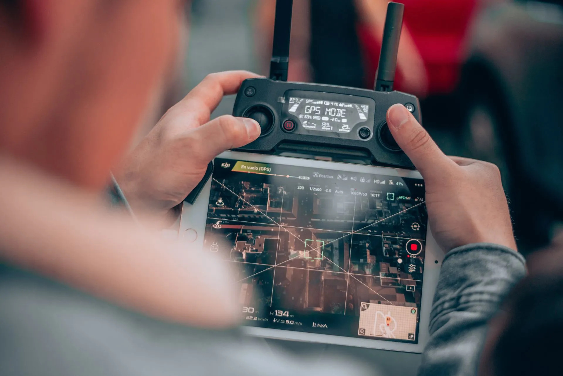
5 Reasons You Should Consider A Career As a Drone Pilot!
Have you ever considered jetting around the globe as a commercial airline pilot? Sounds glamorous and exciting, right? Wrong! In this article, I am going to tell you how you can still fly high, make great money, and have a rewarding career as a Drone Pilot! For the last 40 years I have travelled the world as an airline pilot
Read More
4 Steps To Start Your Career In The Canadian Drone Industry
If you're thinking about switching careers or looking for a side gig there has never been a better time to get started in the Canadian Drone Industry. The North American drone industry continues to expand and grow in both the U.S. and Canada. In fact, by 2021, BI Intelligence has predicted that drone sales will be
Read More
The Canadian Drone Institute Featured On Globalnews.ca!
Students at NSCAD (Nova Scotia College of Art and Design) University will be learning how to legally operate drones and use it in visual arts practice, capturing photos of infrastructure, forests or oceans. It’s part of a newly launched drone photography class this summer in Halifax. Drones, also known as remotely
Read More